The FAO (Food and Agriculture Organization of the United Nations) has divided the world’s oceans into major fishing areas, officially called FAO Major Fishing Areas, to standardize global fishery statistics and management.
These codes are used widely in fishery science, seafood labeling (including sardines and other canned fish), and in sustainability certifications like MSC. Some, but not all, tinned fish products may have the FAO number and designation on their cans in addition to, or in place of, country of origin.
Here’s a list of all 19 FAO Major Fishing Areas, including their numeric codes and regional names:
FAO Major Fishing Areas
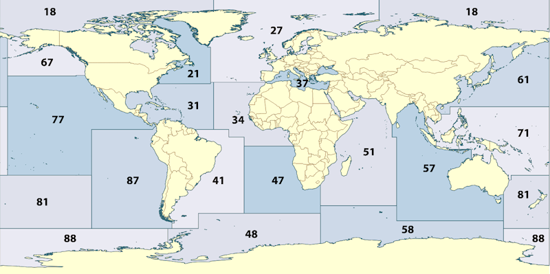
| Area Code | Official Region Name |
|---|---|
| 18 | Arctic Sea |
| 21 | Atlantic, Northwest |
| 27 | Atlantic, Northeast |
| 31 | Atlantic, Western Central |
| 34 | Atlantic, Eastern Central |
| 41 | Atlantic, Southwest |
| 47 | Atlantic, Southeast |
| 48 | Atlantic, Antarctic |
| 51 | Indian Ocean, Western |
| 57 | Indian Ocean, Eastern |
| 58 | Indian Ocean, Antarctic |
| 61 | Pacific, Northwest |
| 67 | Pacific, Northeast |
| 71 | Pacific, Western Central |
| 77 | Pacific, Eastern Central |
| 81 | Pacific, Southwest |
| 87 | Pacific, Southeast |
| 88 | Pacific, Antarctic |
| 37 | Mediterranean and Black Sea |
Notes:
- These codes are used in fishery reporting, labeling, and sustainability certifications (e.g., on canned fish labels).
- Each major area is often further subdivided into statistical sub-areas or divisions for more detailed reporting.